Prairielands Groundwater Conservation District
Mission
The Mission of the Prairielands Groundwater Conservation District (“District”) is to develop rules to provide protection to existing wells, prevent waste, promote conservation, provide a framework that will allow availability and accessibility of groundwater for future generations, protect the quality of the groundwater in the recharge zone of the aquifer, ensure that the residents of Ellis, Hill, Johnson, and Somervell Counties maintain local control over their groundwater, respect and protect the property rights of landowners in groundwater, and operate the District in a fair and equitable manner for all residents of the District.
Creation
The Prairielands Groundwater Conservation District (“District”) was created by the 81st Texas Legislature under the authority of Section 59, Article XVI, of the Texas Constitution, and in accordance with Chapter 36 of the Texas Water Code (“Water Code”), by the Act of May 31, 2009, 81st Leg., R.S., Ch. 1208, 2009 Tex. Gen. Laws 3859, codified at TEX. SPEC. DIST. LOC. LAWS CODE ANN. Ch. 8855 (“the District Act”). The District is a governmental agency and a body politic and corporate. The District was created to serve a public use and benefit, and is essential to accomplish the objectives set forth in Section 59, Article XVI, of the Texas Constitution.
Directors
The District’s Board of Directors (“Board”) consists of eight members who are appointed by the county commissioners courts for four-year terms. There are two members on the Board for each of the four counties in the District. One director is appointed per county every two years; therefore, each county has one director with a term that expires every two years.
Click here to view a list of the PGCD Board of Directors
Authority
The District has the rights and responsibilities provided for in Chapter 36 of the Texas Water Code and Chapter 356, Title 31 of the Texas Administrative Code. The District is charged with conducting hydrogeological studies, adopting a management plan, providing for the permitting of certain water wells, and implementing programs to achieve statutory mandates. The District has rulemaking authority to implement the policies and procedures needed to manage the
groundwater resources of Ellis, Hill, Johnson, and Somervell counties.
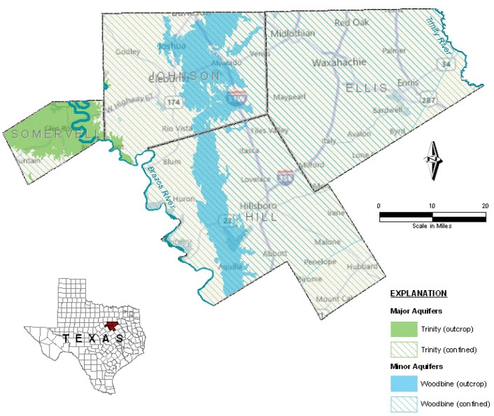
Location and Extent
The District’s boundaries are coextensive with the boundaries of Ellis, Hill, Johnson, and Somervell Counties, Texas. The District covers an area of approximately 2,864 square miles.
Topography and Drainage
The District is located within the Brazos and Trinity River Basins. Runoff on the west side of the District flows primarily west to the Brazos River, and runoff on the east side of the District drains primarily to the east to the Trinity River. Elevations in the District range from approximately 400 to 1,000 ft. above mean sea level (amsl) and the physiography consists primarily of gently rolling prairieland, woodlands, and wooded bottomlands in the river valleys.
Groundwater Resources of Ellis, Hill, Johnson, and Somervell Counties
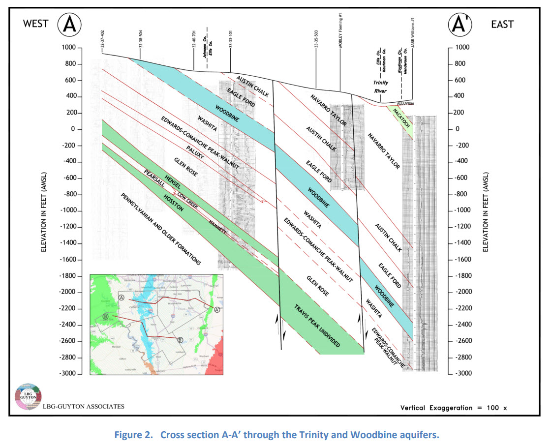
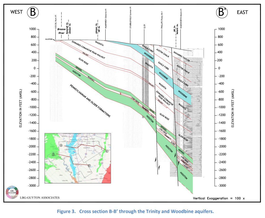
The Trinity aquifer consists of early Cretaceous Period formations of the Trinity Group where they occur in a band extending through the central part of the state in all or parts of 55 counties, from the Red River in North Texas to the Hill Country of South-Central Texas. Trinity Group deposits also occur in the Panhandle and Edwards Plateau regions where they are included as part of the Edwards-Trinity (High Plains and Plateau) aquifers.
Formations comprising the Trinity Group are (from youngest to oldest) the Paluxy, Glen Rose, and Twin Mountains-Travis Peak. Updip, where the Glen Rose thins or is missing, the Paluxy and Twin Mountains coalesce to form the Antlers Formation. The Antlers consists of up to 900 feet of sand and gravel, with clay beds in the middle section. Water from the Antlers is mainly used for irrigation in the outcrop area of North and Central Texas. Forming the upper unit of the Trinity Group, the Paluxy Formation consists of up to 400 feet of predominantly fine-to-coarse-grained sand interbedded with clay and shale. The formation pinches out downdip and does not occur south of the Colorado River.
Underlying the Paluxy, the Glen Rose Formation forms a gulf-ward-thickening wedge of marine carbonates consisting primarily of limestone. South of the Colorado River, the Glen Rose is the upper unit of the Trinity Group and is divisible into an upper and lower member. In the north, the downdip portion of the aquifer becomes highly mineralized and is a source of contamination to wells that are drilled into the underlying Twin Mountains.
The basal unit of the Trinity Group consists of the Twin Mountains and Travis Peak formations, which are laterally separated by a facies change. To the north, the Twin Mountains formation consists mainly of medium-to coarse-grained sands, silty clays, and conglomerates. The Twin Mountains is the most prolific of the Trinity aquifers in North-Central Texas; however, the quality of the water is generally not as good as that from the Paluxy or Antlers Formations. To the south, the Travis Peak Formation contains calcareous sands and silts, conglomerates, and limestones. The formation is subdivided into the following members in descending order: Hensell, Pearsall, Cow Creek, Hammett, Sligo, Hosston, and Sycamore.
Extensive development of the Trinity aquifer has occurred in the Fort Worth-Dallas region where water levels have historically dropped as much as 800 feet and greater. Since the mid-1970s, many public supply entities have inactivated wells and shifted to surface water supplies, and water levels in some areas have responded with slight rises. Water-level declines are still occurring in areas. The Trinity aquifer is most extensively developed from the Hensell and Hosston members in the Waco area, where the water level has declined by as much as 400 feet.
The Woodbine aquifer extends from McLennan County in North-Central Texas northward to Cooke County and eastward to Red River County, paralleling the Red River. Groundwater produced from the aquifer furnishes municipal, industrial, domestic, livestock, and small irrigation supplies throughout its North Texas extent. The Woodbine Formation is composed of water-bearing sandstone beds interbedded with shale and clay. The aquifer dips eastward into the subsurface where it reaches a maximum depth of 2,500 feet below land surface and a maximum thickness of approximately 700 feet.
The Woodbine aquifer is divided into three water-bearing zones that differ considerably in productivity and quality. Only the lower two zones of the aquifer are developed to supply water for domestic and municipal uses. Chemical quality deteriorates rapidly in well depths below 1,500 feet. In areas between the outcrop and this depth, quality is considered good overall as long as ground water from the upper Woodbine is sealed off. The upper Woodbine contains water of extremely poor quality in downdip locales and contains excessive iron concentrations along the outcrop.